blazonKoenigsberg

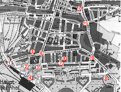
A long time ago, when nobody heard about the computers our Kaliningrad was Koenigsberg. And here you will see how it was looking like before the name and citizenship change, approximatly in 20-30th of XX century. If an profound ideas and a wishes to share them will come to you after what you will see here then you can e-mail me - I will be glad to take them into account when making new pages about further exhibitions devoted to that theme.

An exhibition became available only after when Alexey Zatopliaev kindly supplied his materials.

Here you see the Koenigsberg central part map. The place of each photo is marked by a figure (1, 2. ... 12) on the map. To view a photo image corresponding to number on the map just click the mouse on the figure you wish. And if you wish to take more particular look on city part map, just click on it on the map.

And something more, I have a doubt about the photos location adequacy to the places pointed on the map. If you have more accurate information, please let me know, I will be thankfull to you.


If you want to look at the Old Koenigsberg pictures one by one you can do it right below, also you will see pictures of the places not known where they were located in Koenigsberg map.

First photo First photo
To exhibition Page To EType HOme Page
© 1998, Oleg Duletsky,
Viacheslav Mamontov
«E T Y P E Internet Server»